

Regional Rainwater Harvesting Potential Mapping through Geoinformatics
- Geoinformers
- Jul 28, 2024
- 4 min read
The Regional Water Harvesting Potential Mapping Project implemented by #ICARDA & #FAO and funded by Swedish International Development Cooperation Agency ( #SIDA). This initiative is a pivotal initiative aimed at addressing water scarcity in the Near East and North Africa ( #NENA) region, which is particularly vulnerable due to its #dryland environments. This project emphasizes the importance of rainwater harvesting technologies (RHTs) as a sustainable solution to enhance agricultural productivity and mitigate the impacts of #climatechange.

Fig: RWHI Computation Approach
The project is part of a broader effort under the FAO regional initiative, which focuses on enhancing water efficiency and sustainability in NENA countries. It aims to assess the scaling-up potential of water harvesting practices, ensuring that water resources are managed strategically. This involves setting sustainable limits on water consumption and maximizing the use of every drop, including non-conventional water sources.
I got the opportunity to work on this project during my association with ICRADA under the leadership of senior climatologist Dr. Ajit Govind. All of the Decision Support Tools on this website were conceptualized by Dr Ajit and programmed & developed by Dr Gopal Krishna. One of the tools was developed by Ms. Saumyta. I feel happy to be the part of such initiative.

Decision Support Tools/ Web Applications-
Hydro climatology
The Climate Dynamics of the NENA region is significantly influenced by various hydrometeorological factors, which determine the potential for rainwater harvesting. Precipitation patterns are crucial for water input, while temperature, wind, and radiation affect evapotranspiration (ET) processes.
This module will generate the time series of the selected meteorological variable for the user-specified time-periods for any location in any of the selected NENA countries. The map generated is the average monthly map of the selected meteorological variable.
Link: Climate Dynamics of the NENA region – Regional Water Harvesting Potential Mapping Project (mena-rainwater.org)

Figure: A DSS for hydro climatology mapping
Biophysical Factors
The Dynamic Mapping of Biophysical Drivers focuses on the various biophysical factors that influence the water balance of landscapes, which is vital for assessing rainwater harvesting potential. Key categories of these factors include:
Hydroclimatic Factors: These encompass precipitation patterns and temperature, which directly affect water availability.
Edaphic/Soil Related Factors: Soil properties influence water retention and infiltration rates, impacting how effectively rainwater can be harvested.
Geomorphological Factors: The landscape's physical features, such as slopes and landforms, play a crucial role in water flow and accumulation.
Vegetation Related Factors: Vegetation cover affects evapotranspiration rates and soil moisture levels, influencing the overall water balance.
Geological Factors: The underlying geology can affect groundwater availability and the movement of water through the landscape
Link: Dynamic Mapping of Biophysical Drivers – Regional Water Harvesting Potential Mapping Project (mena-rainwater.org)
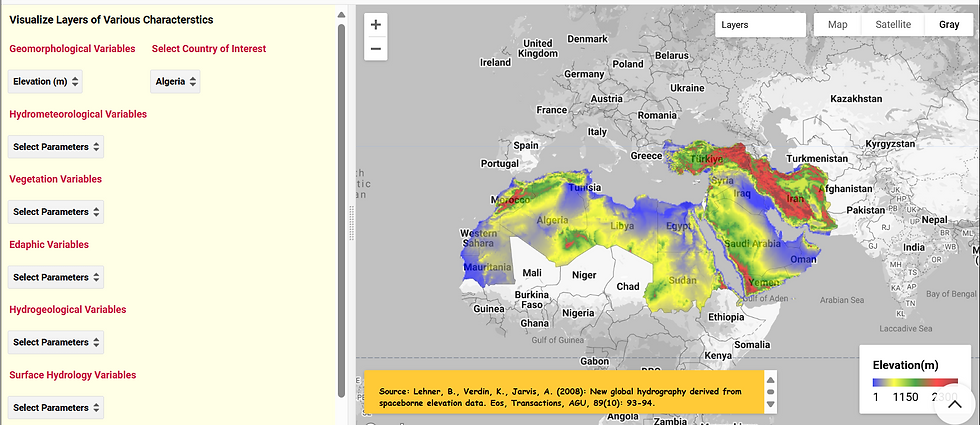
Figure: A DSS for dynamic mapping of biophysical drivers
Water Balance Analysis
The Water Balance of the NENA Region analyzes the hydrological cycle using high-resolution monthly climate data averaged over 15 years. Key highlights include:
Visualization: Users can view water balance data for specific locations, aiding in localized assessments of water availability.
Soil Water Storage: Over long periods, changes in soil water storage (ΔS) typically approach zero, indicating a balanced water cycle, but deviations suggest rainwater harvesting potential.
Regression Analysis: The project uses regression equations to assess the sustainability of water resources in the region.
The tool let you draw a polygon on map and shows statistics for AET, Rain, runoff and DeltaS. This analysis is essential for developing effective water management strategies and enhancing rainwater harvesting practices in the NENA region.
Link: Analysis of Water Balance of the NENA Region – Regional Water Harvesting Potential Mapping Project (mena-rainwater.org)

Rainwater Harvesting (RWH) Potential Zonation
This tab has two tools: RWH Index (RWHI) and RWHI Sensitivity Analysis.
The Mapping Rainwater Harvesting Potential initiative by ICARDA focuses on assessing the feasibility of rainwater harvesting in the NENA region, which is significantly impacted by water scarcity. This project employs spatial analysis to identify areas with high harvesting potential based on factors like precipitation, soil characteristics, and topography. It evaluates various rainwater harvesting techniques for their effectiveness and estimates the potential water yield from these practices. By prioritizing regions with the greatest need, this mapping effort aims to enhance agricultural productivity and food security, providing valuable insights for policymakers and local communities to implement sustainable water management strategies.
The Sensitivity of Rainwater Harvesting Potential within the ICARDA project analyzes how changes in key biophysical factors, such as precipitation and soil characteristics, affect rainwater harvesting in the NENA region. This analysis employs spatial modeling to assess the impact of these variations and simulate different scenarios, including climate change effects. By mapping the sensitivity results, the project identifies areas vulnerable to changes in harvesting potential, enabling policymakers to make informed decisions regarding water management strategies and adaptation to future challenges.
By understanding the sensitivity of rainwater harvesting potential to changes in biophysical factors, policymakers and stakeholders can make more informed decisions about water management strategies and adapt to future challenges, such as climate change, in the NENA region.
Links: Rainwater Harvesting Potential Zonation – Regional Water Harvesting Potential Mapping Project (mena-rainwater.org)
Sensitivity of Rainwater Harvesting potential – Regional Water Harvesting Potential Mapping Project (mena-rainwater.org)

Figure: A DSS for Sensitivity Analysis
Regional Statistics Extraction tool
The Regional Synthesis and Statistics on Rainwater Harvesting (RWH) Potential provides a comprehensive overview of the RWH potential across the NENA region. This synthesis includes detailed statistical analyses that highlight the variations in rainwater harvesting potential based on biophysical factors such as precipitation, soil characteristics, and topography. The report emphasizes the importance of understanding these regional differences to effectively implement rainwater harvesting strategies. It serves as a valuable resource for policymakers and stakeholders aiming to enhance water management practices and improve agricultural productivity in water-scarce areas.
Link: Regional Synthesis and Statistics on RWH Potential – Regional Water Harvesting Potential Mapping Project (mena-rainwater.org)
Though it has become a long article, however I hope it's a great website with many relevant RWH tools at one place. All of the DSSs developed can be seen on project website Regional Water Harvesting Potential Mapping Project – By ICARDA (mena-rainwater.org).
Thanks!
Written by Dr Gopal Krishna

Comments